We were delighted to help organise and participate in the Second State of the Map Tanzania in January 2023. It brought together a diverse community of individuals and organizations driven by a common goal: using and contributing to with the theme “Supporting Progress Towards the SDGs with Open Mapping.”
Over 130 individuals from 8+ countries attended, including over 50 YouthMappers students from 17 universities in Tanzania. We had wonderful discussions of new developments, and collaboration on projects aimed at improving OpenStreetMap and open data in Tanzania, promoting cartographic innovation, and using OpenStreetMap as a tool to catalyse progress.
On December 22nd 2022 we talked at State of the Map Nigeria about the journey of the Crowd2map project since it’s origins severn years ago, highlighting the successes as well as challenges the project and its mappers have faced. You can find a link to the slides here and link to the YouTube video here.
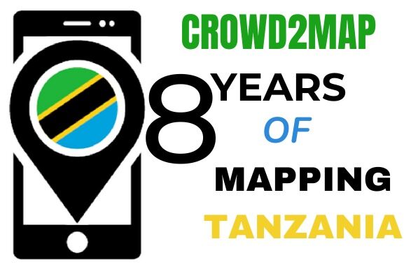
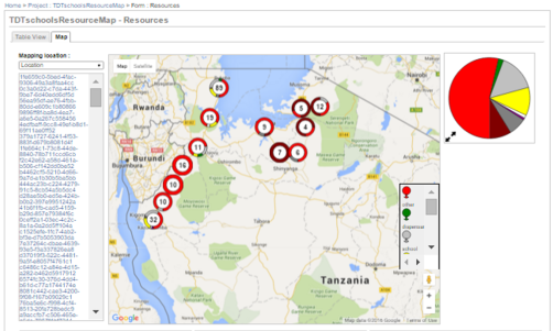
With now over 17,000 volunteers both online and in person, we have managed to map an incredible 5.3 million buildings, over 300,00km of road and over 10,000 Points of Information (POI). It is the combination of our global online mappers with access to complex digital mapping software’s like TaskManager and the local knowledge of our field mappers that continue to make this project so successful and worthwhile. This has saved many vulnerable girls from gender-based violence (GBV) and female genital mutilation (FGM) as well as a tool for development across rural Tanzania. You can see the huge impact of our work by comparing the map of Mugumu before and after our intervention.
Map of Mugumu – Before/ After
Despite these obvious successes, Crowd2map continues to face problems around gender inequality and poverty in relation to in person mappers. While our remote mappers are majorly well educated and with good access to technology, our field mappers live in some of the poorest regions of rural Tanzania, with many never having even used a smartphone or any kind of technology. It is Tanzanian women that are particularly affected by lack of access to the internet. A microgrant we received in 2017 went a little way to buying cheap smartphones that were integrated into the mapping community, allowing for more women to get involved. The gendered stigma around the role and desired characteristics of women, however, continues to limit their potential within the Cord2map project.
Many of the female in person mappers have reported instances in which they have been discouraged from getting involved with mapping from their male counterparts, instead being told they should stay at home and take on more traditional domestic roles. In more extreme cases, women have been victims of physical and/ or sexual violence while undertaking mapping tasks. This is rooted in an inherently sexist culture which continues to limit the potential of women across Tanzania. Women are very unlikely to put themselves forward to lead mapping tasks in comparison to men, despite having more than enough potential to take on these roles.
To tackle this issue, we as a community must do more to educate the Tanzanian locals on the importance and significance of mapping as well as encouraging a more positive and less discriminatory attitude towards women and their capabilities. We can continue to reduce occurrences of physical and emotional abuse from men towards women through education, as well as allowing women to regain their confidence and integrity within the mapping community. Setting up women only mapping groups or requiring at least 50% female participation also goes a long way to reduce this gender inequality.
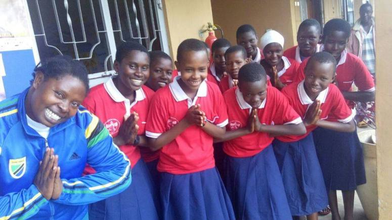
We are making good progress already. With now over 200 women trained to be digital champions, leading the fight against FGM and GBV in Tanzania through mapping, the death rate has fallen by 75%. More than 3000+ girls have been rescued along escape routes discovered through the Crowd2map project, and we continue to look out for important institutions such as police stations that can further our progress, all while encouraging more and more female participation in mapping efforts.
There are so many ways in which you can get involved with the Crowd2map project and contribute to our growing success. You can start by attending some of our upcoming events or visiting this page to get ideas on how you can contribute.
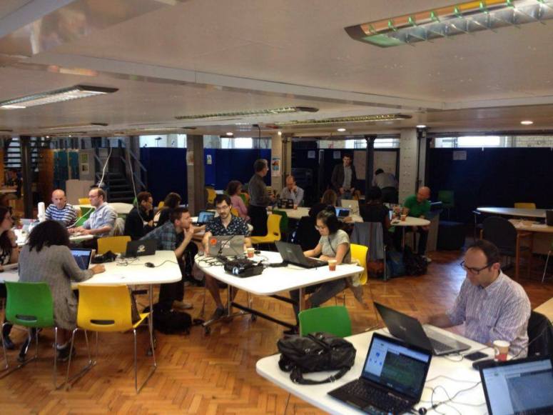
It was wonderful, if slightly overwhelming and sometimes surreal to finally meet so many fellow mappers again at SOTM Firenze last week, as well as so many new friends that I’d only interacted with online. This was my 4th in person event and it reinforced not only how much Crowd2Map has grown since Brussels 2016 but also how the mapping community has changed.
State of the Map 2022
In 2016 arrived in Brussels late at night, a bit disconcerted to find that I was sharing a bed with a stranger – Miriam from GeoChicas. We quickly got over this surprise and she became a great friend and ally, even visiting the FGM Safe Houses we work with in Tanzania en route to FOSS4G 2018. In Brussels I was a newcomer who knew no one. I tried to navigate the seeming chasm between the brown shirted craft mapper gang and the humanitarian team. In Firenze I was very pleased to note much less of this divide. Arriving felt like coming home after a long journey, meeting so many people from previous events and others for the first time IRL.
Particular highlights for me were talking about the impact of our Digital Champion project, meeting colleagues from Missing MapsHOTand Youthmappers who I’d only interacted with online. Kristen Tonga’s talk on the challenges of mobile mapping in rural Tanzania really resonated with our experiences setting up our Digital Champions program, and we look forwards to working with her going forwards.
Ilya is always enthusiastically working on something interesting and this year was no exception, we’re looking forwards to working with him on Every Door soon. The We’re also looking forward
Greatly looking forward to next meet up – particularly State of the Map Tanzania in January 2023 and hope to see many of the mapping community there either in person or online!
Crowd2Map Tanzania has a cohort of 16,000 volunteers based in Tanzania and around the world, all of whom are driven by a passion to help rural communities in Tanzania and to ensure girls and women in these areas are empowered. As we celebrate 6 years of mapping, we take a look at some of the work and partnerships that we have developed to ensure Tanzania is mapped.
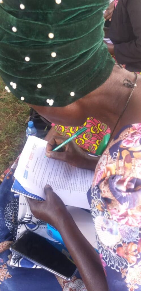
Crowd2Map Tanzania has been training local activists (NGOs), Local Government, communities and Youth Mappers Chapters in Tanzania on open data and mapping and how can they integrate mapping knowledge with their activities to solve community challenges.
Some of the tools used for mapping and open data that Crowd2Map has been training these group on are:
Smartphone applications such as Maps.me, OSMAnd, ODK and Mapillary for mapping features around their community and collecting data for different uses
Other tools that require the use of a computer for mapping and Data collection such as ID Editor, JOSM and Kobo toolbox
Some of the NGO’s have managed to win Community mapping microgrants and are running projects in their communities in various areas in Tanzania to share mapping and open data knowledge with a wider audience.
Tanzanian NGOs who have been trained include:
Agri-Thamani based in Bukoba Tanzania are running garden community mapping and Schools mapping project in their community
Red Cross Katavi community are mapping vulnerable areas around Mine sites in Katavi
Good Harvest Organization who were trained in the use of Open Data Tools and other internet-enabled devices
LAVISHENI group in Mwanza mapping vulnerable areas for GBV cases in their community
Institute of Rural Development and Planning College in Dodoma Youth mappers are mapping Dump sites in Dodoma
Serengeti Tourism College Youth Mappers are involved in mapping health centre facilities in Mugumu-Serengeti
Institute of Accountancy in Arusha (IAA) Youth Mappers, Tumaini College in Arusha Youth Mappers, Institute of Rural Development and Planning Youth Mappers in Mwanza are still continuing with mapping Training.
Miller’s Group in Muleba Tanzania, Kibondo mapping Group, ESTL NGO are still continuing with mapping and Open Data training.
Local Government in Serengeti and Singida are now involved in mapping and Open data training conducted by Crowd2Map.
We are seeing a great deal of interest from these local and broader organisations who are understanding of the benefit of accurate maps for the growth of Tanzanian communities.
Crowd2Map’s partner, Hope for Girls and Women Tanzania is among seven organizations that have been awarded an Open Map Development Tanzania (OMDTZ) Community Impact Microgrant of $5000. OMDTZ selected recipient organizations with the intention;
The grants provided will support these communities to leverage the use of OSM and mapping to help solve different community challenges.
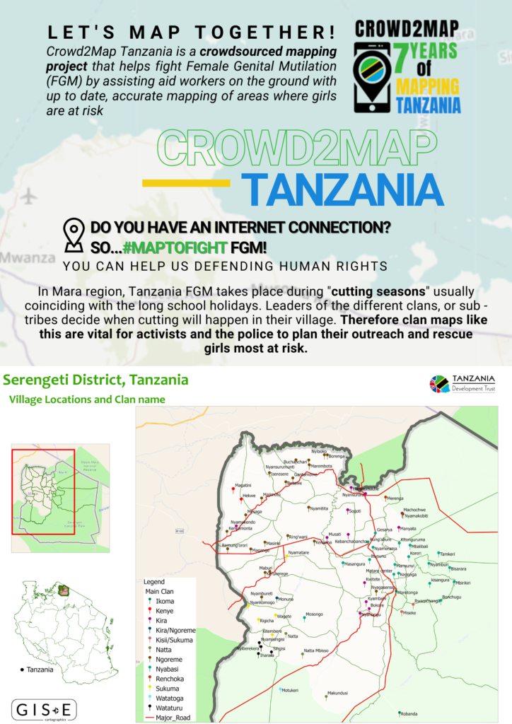
Hope will use the grant to expand the existing Open Street Map (OSM) Community around Mugumu, Serengeti. By improving our maps of the region, we are able to provide better, faster reaching, efficient support and advice to girls and women who are at risk of, or who have been through, female genital mutilation (FGM) and gender-based violence (GBV).
The grant will help the Hope team to recruit 25 new OSM community mappers around Mugumu, who will be trained on how to use different tools that support mapping, including:
Maps.me application
ID editor
JOSM
They will also receive training in how to use Open Data Kit Collector for Data Collection.
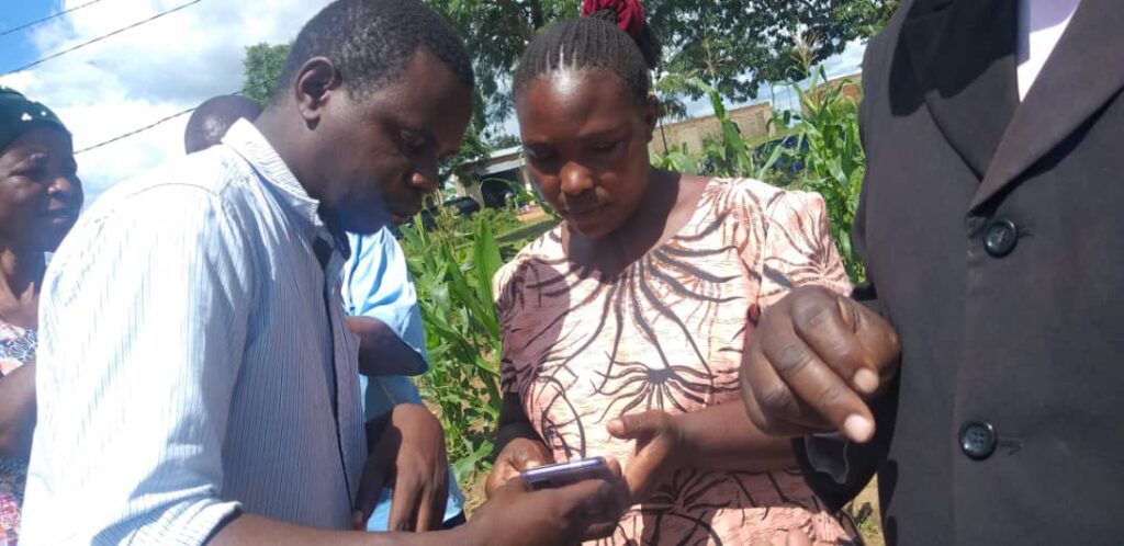
A lot of this training will involve the use of smartphones.
The goal is to map all of the health center facilities available in 30 villages around Mugumu, showing the services provided at each, and if the center facilities are adequate in relation to the community population.
The grant will additionally the team to buy equipment such as laptops, smartphones and routers which are critical for the work being done. They will also be able to rent a hall for workshops and training, provide transportation for data collection, and support other logistical requirements for a period of six months.
At this point, findings will be presented back to the community and Hope will also create a map of each village, showing the health center facilities that are available.
75% of the new mappers will be female, which helps to promote and encourage the inclusion of women in technology and OSM. We are seeing increasing numbers of women wishing to train and contribute to maps, and they are also getting a lot of enjoyment from seeing the benefits of technology on their daily lives and that of the local community.
We are excited to be welcoming to the workshop and training Mara Red Cross and SETCO Youth mappers who will be involved to learn more about how mapping can help solve community challenges.
We look forward to bringing you further updates on this Microgrant and the project in general.
Read more about why maps are so important for Tanzania and even get involved as a virtual volunteer. Mapping is protecting girls from Tanzania by ensuring help is able to reach them faster – and often time is of the essence.
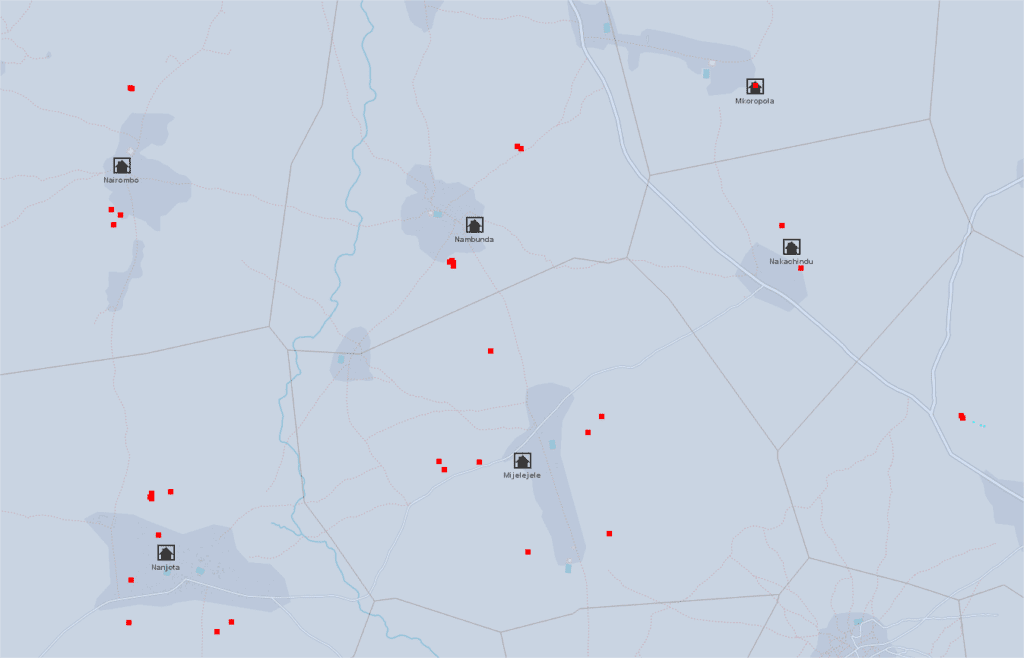
Knowing the vast, rural area of Tanzania is crucial to provide timely and effective help for girls during Female Genital Mutilation (FGM) ‘cutting seasons’. In recent years, we have managed to map millions of buildings which can help us determine the distribution of the population. Although low population density areas in Tanzania are not sufficiently mapped yet, the initial steps have already been taken.
Goals of mapping
Crowd2Map Tanzania is a “crowdsourced mapping project aiming to put rural Tanzania on the map”. A primary goal is to help fight against FGM. Girls are rescued and taken to safe houses by local volunteers and police. However, for this they need maps. But maps can do more than just show these rescue teams the way to remote villages. The existence of spatial information can help with development and to increase commercial efficiency and economic growth opportunities for businesses and entrepreneurs, giving them the opportunity to make better-informed decisions. Growing wealth improves the quality of life, gives a chance for more opportunities and a better quality of education.
Find the village
So, we now know where to find traces of human settlements, but how do we delineate each settlement and, more importantly, how do we know what the name of the settlement is?
The delimitation of human habitats is not easy, the structure of the settlement is often region dependent. What does it mean? In the Ruvuma region (southern Tanzania) the settlements are well separated on the map. In contrast, in agricultural areas of the Shinyanga region, delimitation sometimes seems an impossible task.
And what about the names of the settlements? Local volunteers can help us identify all the names of circa 10,000 – 12,000 settlements in Tanzania, OR we can try to find some open source data which contains this information. Recruiting hundreds of volunteers from all over the country is beyond our power, so we need to focus on the second SOLUTION in most places. Fortunately, we have some open source data from The United Republic of Tanzania – Government Basic Statistics Portal, like health facilities or schools, or waterpoints located all over Tanzania.
Our project objective is to add the missing village names in Tanzania, using open source government data about water sources in Tanzania.
Water Points Location in Rural Water Supply – 2015-2016
Method for the estimation of village position
The shared database contains about 87,000 water sources, which can be lakes, rivers, machine drilled boreholes or springs. The database also contains the physical condition (quality, quantity) of the water sources as well as their spatial location, indicating, for example, the village name where the water source is, or the nearest village to it. This data helps us determine the name of the village in OSM.
Workflow
For data validation the best possible application is JOSM, which can prepare our data to upload to OSM after data validation. During validation, the next datasets and imagery were used:
Thyessen polygons were calculated from the water points layer, to get the influence zone of each water point. Then, the polygons were merged by attribute, where the village name is the same. The resulting polygons can help to determine the area where the village has to be.
In the same time, Mean center was calculated for the points inside a polygon → potential position of the village. (Since in a few cases the name of a village occurs more than once in the country, a “village+district” combined data was used to help us to find the real mean center.) This is our village data POI which need to be implemented to OSM.
OpenStreetMap imagery was used to identify the trace of human activity if the area was well mapped. We were also able to get an answer as to whether the name of the settlement has already been given to OSM.
Maxar satellite imagery was used for those areas that weren’t mapped yet.
Other useful datasets for validation
Waterpoints: can be really useful, if the position of the village’s POI is unusually far from any populated area. In this case, it is worth looking at how each water point is located in the area. Another example, when the village consists of two sub-villages, then the “SUBVILLAGE” attribute of the water database can help determine where the center of the village can be.
Health facilities data: The government data contains more than 7,000 health facilities like hospitals or clinics. The names of these facilities are usually, but not exclusively, the same as the name of the municipality where it is located.
Education data: The government data contains almost 7,000 schools. The village names are available in this data.
In summary
The Voronoi polygon assigns the area where the village is located (or has to be). The village POI assigns the potential location of the settlement, BUT its accuracy depends on the number of water abstraction points and their location in/around the given settlement.
In a well-mapped area – where, moreover, the settlements can be easily separated from each other – we did not have a difficult time with validation (mean centers before validation). The mean center of the Waterpoints sometimes clearly shows the center of the settlement if these water points are evenly distributed within and around the settlement.
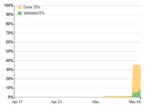
Provisional results
By the end of September, more than 143 districts were validated (88% of all districts), and 5505 villages POIs were added which is 52% of the total village POIs in Tanzania.
User name
Total edits
Bgabor
1802
SHABANI MAGAWILA
2255
Kasunga
884
Stuart Ward
49
Number of edits by users – which was added with “TNZ_missing_villages” hashtag
Crowd2map volunteers in the lead
The OSM database currently contains 10483 Tanzanian village points, a significant part was added by the volunteers of the Crowd2map team. The following pie chat shows how this 10483 POIs is divided between the TOP5 volunteers and the rest of mapper community:
Updated results – 31/10/2020
By the end of October, more than 157 districts were validated (97% of all districts), and 6759 villages POIs were added.
Crowd2Map had a great time presenting at Mozfest in London last weekend. We had a session in the science fair on Friday night and signed up a lot of new people to help map the area of Serengeti where girls are most at risk of Female Genital Mutilation via mapping from satellite images here. Then we delivered a workshop on Sunday to actually get people mapping (all the notes from the session can be found in the Etherpad here), complete with a live link to the Safe House in Mugumu, and presented our map at the show party on Sunday.
Coupled with doing 4 interviews, meeting hundreds of amazing people and even being chased by monks it was a brilliant weekend. BUT, on a serious note, we are desperately trying to get the map of Serengeti complete before the FGM cutting season starts in 3 weeks time. Please help us here.
8 mappers in Vilnius, 26+ in London, 32 in Dar, 15 in Nairobi, 15 at Mugumu Safe House and many others online joined our mapping party last Saturday!
Thanks to all of you we were able to map over one third of the entire region in Mara!!
Congratulations all users who were able to map an amazing number of squares. You can also check your own contribution on roads and buildings here.
Thanks also to Polyglot and robert, who have been validating our squares so far !!
I’m not so good with numbers though, and frankly, I don’t think they speak justice to what we have accomplished during our Triple Mapping Party! So I am going to tell the rest of the story in notes and pictures instead…
Great work, I am with you from Zeze village – Benedicto
…and Tunapanda from Nairobi! Thanks so much guys!!
15 of us learning to get our map on in Kibera, Nairobi – Jay
Girls at Mugumu Safe House took matters into their own hands and joined us in mapping all day!! Thanks to Rhobi who takes care of the safe house, IT teacher Irene, roadshow Emanuel & the girls at the safe house!
We are very excited to map our Tanzania, here with Madam Rhobi – Irene
Congratulations everyone who participated in the mapping! Hongereni Sana! – Rhobi
We ended the session with so much smile – Irene
More mappers in London!
London in action – Andrew
Happy mapping in Dar!
And finally…
Appreciations and so much thanks from the Safe House for great experience acquired during mapping – Rhobi
Remember: NOW is only the beginning… we’ll continue to map together, part of Crowd2Map Tanzania!!
Thanks to some nifty tools recently developed in the OSM community, we’ll be able to visualize our impact with OSM analytics!
Playing about with it just now, I discovered that already a noticeable amount of work has been done in 2016, partially thanks to our mapping volunteers!! Blank canvas is already turning into something resembling a map, see for yourself:
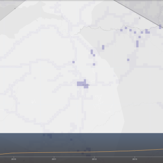
Roads before 2016:
… and now (4 months into 2016!):
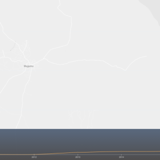
Buildings around Mugumubefore 2016:
… and now (4 months into 2016!):
We hope our Mapping Party will paint that into a multitude of colours!
Which team will map the most? Vilnius? London? Dar?
Crowd2Map used to be run via EpiCollect+ platform, which allows locals to install an app on smartphones or tablets and register various resources and villages through a simple data collection form. By setting coordinates, attaching a photo and answering a few questions, each point can be registered in minutes.
The data is then sent to the central server, and all the data points can immediately be visualised on a map via the browser:
In December 2015, Janet took some donated tablets and smartphones to several schools in Tanzania and kicked-off the data collection. Several months past, we already have over 200 points!
[update 2016-04-10] We now have nearly 1500 pointson EpiCollect+!