Blogs

Using mobile technology to improve the farming of crops in Tanzania

Farmers receive training

On 26th April 2021, Hope for Girls and Women kicked off a programme of agri-technology farmer training in Matare, Serengeti. This exciting collaboration between Hope and PlantNuru, Kenya, provided training that explored the use of digital technology to help farmers protect their crops. Not only does this support the local community with their work, but also provides the opportunity to engage attendees in education and conversation around gender-based violence.

Farmers explore practical training

There were 20 farmers and 7 community leaders involved in the two-day session which was opened by Serengeti’s District Executive Director.  The District Agricultural Officer and District Community Development Officer were also in attendance.

Day one covered the types of disease that can be found in cassava and Maize and how to differentiate between diseases and their impact to crops.

The team then looked at the approaches that can be used to mitigate the infection of these crops, providing a solution on how to plant cassava and maize when you want to increase your production and possible ways of planting cassava for seed.

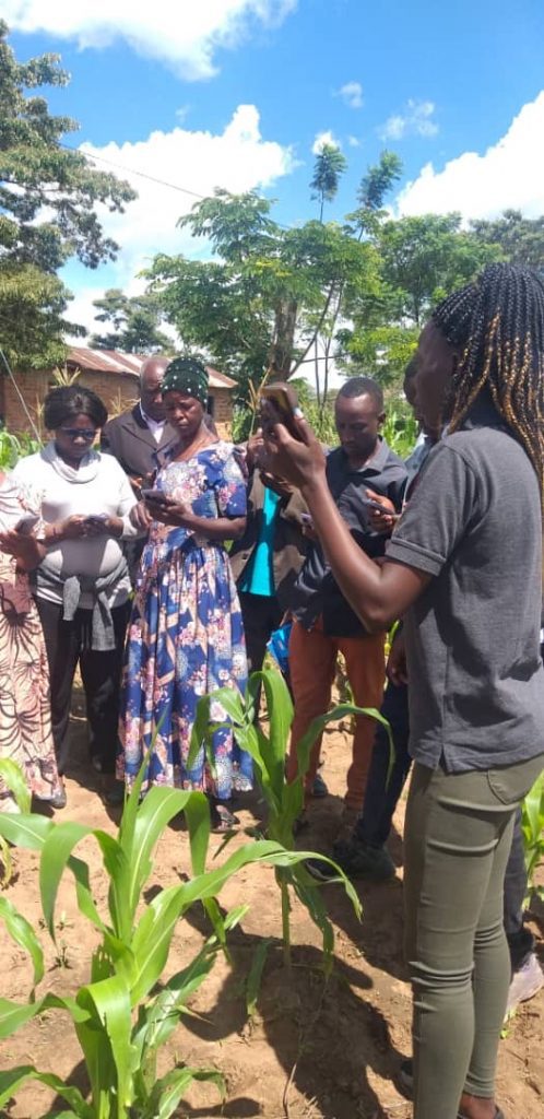
Day two included a practical session on how to record crop-type data by using PlantVillage app. This included a visit to a maize and cassava farm where disease identification exercises were carried out. Attendees were shown how they can use the  PlantVillage app for the detection of diseases and Pests. Farmers can seek advice from extension officers who are close by as well as from other users, using the app.

This is an innovative new stepping stone for farmers to benefit from agri-technology, which will help the production of their crops.

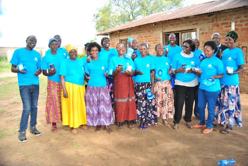
Twenty farmers were given smart phones at the end of the session.  As well as the PlantVillage app, their phones were installed with maps.me and the ODK form to support the reporting of GBV/FGM cases. All farmers signed the contract upon receiving their phones to commit to use their phones for the targeted work.

20 farmers participate in training

There was very positive feedback from the farmers involved in the session who welcomed this opportunity to enhance their output and support their local community, including vulnerable girls and women.

The PlantVillage app can be downloaded on the GooglePlay and Apple App Store.

MAPPING SMALL SCALE MINING IN KATAVI REGION

Due to its geological framework, Katavi region is endowed with abundant mineral deposits of different kinds including gold, green tourmaline, gemstone, and copper Most of mining activities are conducted by small scale miners. Gold in the Region of Katavi are found in the following areas  Ibindi, Ugalla, Singililwa, Msagiya Kampuni and Mpanda town.

Miners and processors are a highly dynamic group of people. Particularly in gold mining, there are a lot of rushes in the Region of Katavi that may see thousands of workers come and go in a matter  of months. 1 in 3 workers arrived from a different region, and  many others travel within these vast regions in pursuit of employment opportunities. Often, sites have no adequate infrastructure to deal with the influx of workers. Over half of workers operate on a site that has a makeshift camp where workers live and sleep. 

When we visited most of the mining sites in the Region we found that women benefit considerably less from this mineral wealth than men. They remain stuck in lower level positions; they are mainly engaged in processing activities such as crushing and panning. Mining remains a patriarchal sector where men are protective of their positions. As sites are also ill-adapted to women, with, for instance, only few sites having separate sanitary facilities. Paradoxically, most sites cannot function without women, who provide the bulk of support services such as serving food, selling drinks, maintenance and transporting supplies. Another problem prevalent in the mining sites in the Region of Katavi is the problem of child labour. Although illegal, their involvement in mining is widespread. In about half of sites with child labour, children seen working during school hours.

Health and safety are a pressing concern in most mining sites.  There is no access to sanitary facilities in many sites, and where there are available, they are in poor condition or insufficient in number. Combined with the lack of clean drinking water, dust and noise pollution, mines are a breeding ground for numerous infections and disease.

Mining activities also severely impact the environment in Katavi through water pollution, deforestation and land degradation.

Considering these challenges, it is clear that considerable work remains to be done in enforcing the law on these sites. 

Good Harvest Organisation, in conjunction with the local Red Cross, are mapping the mining the mining sites by training its members and equipping them with mobile phones and open-source mobile data collection applications to capture coordinates, take  pictures and complete dedicated questionnaires, to bridge information gaps around mining in the region of Katavi. This will be done in two main phases.

The first phase will consist of a broad mobile survey on the socio-economic and human rights impact of mining in the region. we will survey all communities around mines on their perceptions regarding the impact of these operations. The findings of this data collection will be published and given to the key stakeholders.  This data will enable hands-on follow-up by the Government of Tanzania and local NGOs.  

Celebrating women in mapping: Lowri Harris

This month we have been celebrating just some of the women around the world who contribute to our work to eradicate FGM in Tanzania.

This week, Lowri shares her experience of mapping over the last seven months.

What are you doing currently: I am currently a second year student studying BA History at the University of Exeter in the UK.

Why this cause:  I came across this cause through the United Nations online volunteer website and it instantly appealed to me. Participating in mapping feels like such a simple way to make such a huge difference to real people’s lives from behind my laptop. Mapping is super enjoyable whilst also helping a wonderful cause. I feel really passionate about the goal of the Tanzania Development Trust in attempting to prevent the awful cases of FGM that are happening in Tanzania. I think as a young female, the cause really resonated with me and I felt super keen on trying to help. It has really made me appreciate even more the safety of where I am fortunate enough to have been born and live. Furthermore, I have enjoyed the challenge of learning how to map as I was completely new to it so I feel like I have gained a new skill in the 7 months I have been mapping for!

Find out more and get involved here

Celebrating women in mapping: Megan Huber

We are continuing our celebration of the many women who support our work as volunteer mappers around the world. Our volunteers make up a global cohort that is collaborating virtually to map rural Tanzania, and help end FGM. We will be releasing a new post each week throughout March:

Picture of volunteer Megan Huber

This week, Megan Huber explains why mapping is important to her and others.

Location: Virginia, USA

What are you doing currently: I’m a contractor in the security and defence sector supporting the development of gender mainstreaming practices and integrating a gender perspective into cross-functional workstreams.

Why this cause: Initiatives that prevent and protect women and girls against any forms of violence are very dear to my heart. I aspire to remain resilient in tackling gender-based violence and volunteering through Tanzania Development Trust reminds me of how violence is not discriminate, but the different forms are depending on many factors (such as age and gender). There are many chances to grow through this initiative, I recommend it!

Why mapping: Being able to volunteer virtually is a lot more convenient for international folk. GIS is a unique skill that I find very interesting, so being able to combine two areas that I like makes this volunteering opportunity very motivating to me!

Mapping since: 2018

Find out more and get involved here

Exploring Open Gender Data for Tanzania

For Open Data Day on March 6th 2021 Crowd2map hosted a webinar on Open Gender Data for Tanzania. We were joined by a number of amazing speakers:

  • Revi Stirling – Director, USAID W-GDP WomenConnect Challenge will talk about financial inclusion and the digital divide.
  • Naledi Hollbruegge, Data Scientist at UNDP. Naledi has a background in Psychology and started her career in social research before becoming a data analyst focusing on self-service analytics tools and data visualisation. She now works with nonprofit organisations to support them in making more data-driven decisions and gain insights through effective data visualisation.
  • Dr Annemarie Middelburg. consultant and FGM expert.
  • Heather Leson, Technologist, Digital Strategy and Partnerships, International Federation of Red Cross and Red Cresent, co-curator Data Playbook
  • Laura Mugeha, Geospatial engineer & YouthMappers Regional Ambassador
  • Christina Reuben, Environmental Scientist, OMDTZ
  • Raya Idrissa Ahmada. Assistant Lecturer at the State University of Zanzibar (SUZA) and a Youthmappers Regional Ambassador. She is also the Founder of Mshauri STEM Initiative with the aim of helping young girls have STEM careers.
  • Theresia Charles Numbi, a CEO of Lighthouse (EA) Legal Clinic (LEALC), Advocate of the High Court and Assistant Lecturer at Tumaini University Dar es Salaam College.
Recording of the Open Data for Tanzania event

There was a very fruitful discussion and the opportunity for networking. In conclusion we agreed that,

 “For progress towards gender equality, we need better identification of issues affecting women and girls.”

The speakers’ slides are here. If you would like to know more about this important issue, and how to get involved, please get in touch.

Celebrating women in mapping: Sharon Omoja

This Women’s Month we are celebrating some of the many women who support our work as volunteer mappers around the world. Our volunteers make up a global cohort that is collaborating virtually to map rural Tanzania, and help end FGM. We will be releasing a new post each week throughout March:

This week we caught up with Sharon Omoja.

Location: Nairobi, Kenya

What are you doing currently: I am currently a GIS Analyst at Naturesurf systems in Nairobi. I volunteer for OpenStreetMap Kenya where I am involved in coordinating some of the community’s activities and training new mappers.

Sharon Omoja - a Crowd2Map volunteer

I also volunteer as a mentor mapper for URISA’s GIS Corps in Crowd2Map Tanzania projects, on mapping to end early child marriages and FGM in rural Tanzania.
Am also part of Women in geospatial where I serve in the mentorship programme, communications working group and Diversity, Equity and Inclusion working group.

Why this cause: I am passionate about matters on humanitarian actions and I have been involved in so many Humanitarian OpenStreetMap Team mapping projects for disaster responses. I also joined URISAs GIS Corps as a volunteer in their project with Crowd2Map Tanzania because I love working on actions that are geared towards achieving SDG5, creating safe spaces for women and girls.

Why mapping:  Data availability is important as it helps to empower various organizations and communities to make important decisions in their work. For example, when we come together and map before a crisis happens, the response is faster. Mapping our community also helps us understand it better, like the resources we have, and how can we utilize them and what’s missing.

Mapping since: I joined OSM in 2016 but started serious mapping in 2018

Find out more and get involved here

Celebrating women in mapping: María Lucía Rodríguez

This month we are celebrating some of the many women who support our work as volunteer mappers, dotted all over the world. Our volunteers make up a global cohort that is collaborating virtually to map rural Tanzania, and help end FGM. They are from all sorts of backgrounds, hold different careers and live in many locations. We will be releasing a new post each week throughout March:

María Lucía Rodríguez

Location: Bogotá, Colombia

Mapping since: October 2020

What are you doing currently: I am an Architect and recently I finished my Master’s Degree in Landscape Architecture in Barcelona, ​​Spain. Currently I work as a freelance developing Masterplans for a few projects.

Maria Lucia Rodriguez

Why this cause: I guess because when I first heard that female genital mutilation existed, I was shocked. I thought it was incredible that something like this still happened today and that being so far away I didn’t know how I could help. When I discovered that I could use my skills and spare time to help women on the other side of the world, I knew I had to contribute.

Why mapping: As an architect, I understand the power of drawing / mapping where and how things are and how they relate to each other. Maps have always been a key tool both in understanding a land and its people and in managing it. You can learn so much from maps and satellite images! I also wanted to learn more about GIS and its applications, and about African geography, as we often don’t know much about it in Latin America.

Find out more and get involved here

Detecting pests in Maize and Cassava with the PlantNuru app

Agriculture is the backbone of the rural economy in Tanzania and the families of girls at risk of FGM and GBV are farmers.

Although in theory there are networks of agriculture extension officers to help them, often in practice they are too far away to be of any use. Therefore, we were very pleased to learn of the PlantVillage Nuru app which seeks to help farmers improve their practice.  In February 2021 TDT  had an online training session for people interested in how to use this free app to detect Fall Army Worm (a pest for maize) and Cassava diseases which was attended by our volunteer and GIS specialist Herry Kasunga. 

Since then he has been out training our Digital Champions to use the app. As maize and cassava are the main staple crops grown in their areas this is particularly important.

Here you can see the Digital Champion for Burunga village, Agness Marinya checking her crops with the app.  She says, “It is an easy way to monitor crops and give you feedbacks on how crops grow, and I will provide training to other farmers in my village.

“With better agriculture people are less likely to need to cut their daughters and sell them for cows.  I have 3 children all girls. I am so proud of my work as a Digital Champion in Burunga, because there have been so much changes in my village.

“Now the number of girls who are cut is reduced. We all need to raise our voices to say no so our children can live free from FGM.”

The slides from our training session are here, and the recording here.  You can also view and download the slides Herry used for training the digital champions below.

Please watch this space for further updates on how this helpful app is being used in Tanzania. 

How mapping is helping Tanzanian villages source water


At the Humanitarian OpenStreetMap Team global conference on Friday December 4 2020, Herry Kasunga talked about the Water Source mapping project that he has been coordinating with the Hope for Girls and Women digital champions.

Herry Kasunga

This is an extremely important project as the majority of people in Mara, as in the rest of Tanzania, are dependent on rainwater for household water, sanitation and to grow their food. It is also estimated that 40% of village water sources are degraded or non-functional. The shots below show some of the water points used by the digital champions:

In addition, climate change further threatens water access and means droughts and average temperature rises are likely, coupled with intense flooding events with significant damage to infrastructure and livelihoods, meaning mapping will become even more important.

Herry’s presentation slides are available here.


Missing villages In Tanzania II

Scene 2 – Find the village

Since the first part of our “Missing villages” project is already in the finish line, we have to explain the second part, which called “Find the village”.

In the first phase, we tried to name the village, now we have to create the village boundaries, if possible. As we said in the previous article, the delimitation of human habitats is not easy, the structure of the settlement is often region dependent. In the Ruvuma region (southern Tanzania) the settlements are well separated on the map. In contrast, in agricultural areas of the Shinyanga region, delimitation sometimes seems an impossible task.

Sources

According to the data created by Digital Globe and funded by the Gates Foundation, approximately 17 million buildings are in Tanzania. By the time that this study was made, the OSM community has mapped circa 11 million building so far, so using buildings data from OpenStreetMap is not enough, we had to use a different source to identify the settlement pattern. To map populations, we used the previously mentioned data from the Gates Foundation and Facebook’s High-Resolution Population Density data for validation.

Workflow

A building aggregation tool was prepared in ArcGIS to aggregate the building footprints (Polygon layer) to produce settlement layers.

  1. At first, buffer building footprints by 50m was created then merged
  2. Secondly, the merged multipolygons were divided into single polygons.
  3. Each settlement patterns area was measured, also the covered buildings were counted for each “building cluster”. These two data can help us to calculate:
    1. Building density (number of buildings / total area)
    1. Number of buildings, which data can help to predict the number of the population
    1. The building density and building number can help in the classification of settlements
      1. Urban or rural area
      1. Settlement type: hamlet, village, or town
  4. During the post-process, sharp angles in polygon were outlined and made smoother to improve aesthetic or cartographic quality. Finally, the unwanted “holes” from polygons were eliminated.

Using this data, we can identify the settlement pattern which can help us creating settlement boundaries for bigger villages, – especially with high building density – and adding to OSM.

In the final steps, first we have to remove those from the resulting settlement boundaries that are already in the OSM database. Secondly – using the validated settlement POIs, we select those settlement boundaries features that contain the village’s point features.

In the end, the selected village boundaries will be uploaded to OSM and will be waiting for phase 3.