Blogs

Missing villages In Tanzania

Knowing the vast, rural area of Tanzania is crucial to provide timely and effective help for girls during Female Genital Mutilation (FGM) ‘cutting seasons’. In recent years, we have managed to map millions of buildings which can help us determine the distribution of the population. Although low population density areas in Tanzania are not sufficiently mapped yet, the initial steps have already been taken.

Goals of mapping

Crowd2Map Tanzania is a “crowdsourced mapping project aiming to put rural Tanzania on the map”. A primary goal is to help fight against FGM. Girls are rescued and taken to safe houses by local volunteers and police. However, for this they need maps. But maps can do more than just show these rescue teams the way to remote villages. The existence of spatial information can help with development and to increase commercial efficiency and economic growth opportunities for businesses and entrepreneurs, giving them the opportunity to make better-informed decisions. Growing wealth improves the quality of life, gives a chance for more opportunities and a better quality of education.

Find the village

So, we now know where to find traces of human settlements, but how do we delineate each settlement and, more importantly, how do we know what the name of the settlement is?

The delimitation of human habitats is not easy, the structure of the settlement is often region dependent. What does it mean? In the Ruvuma region (southern Tanzania) the settlements are well separated on the map. In contrast, in agricultural areas of the Shinyanga region, delimitation sometimes seems an impossible task.

And what about the names of the settlements? Local volunteers can help us identify all the names of circa 10,000 – 12,000 settlements in Tanzania, OR we can try to find some open source data which contains this information. Recruiting hundreds of volunteers from all over the country is beyond our power, so we need to focus on the second SOLUTION in most places. Fortunately, we have some open source data from The United Republic of Tanzania – Government Basic Statistics Portal, like health facilities or schools, or waterpoints located all over Tanzania.  

Our project objective is to add the missing village names in Tanzania, using open source government data about water sources in Tanzania. 

Water Points Location in Rural Water Supply – 2015-2016

Method for the estimation of village position

The shared database contains about 87,000 water sources, which can be lakes, rivers, machine drilled boreholes or springs. The database also contains the physical condition (quality, quantity) of the water sources as well as their spatial location, indicating, for example, the village name where the water source is, or the nearest village to it. This data helps us determine the name of the village in OSM.

Workflow

For data validation the best possible application is JOSM, which can prepare our data to upload to OSM after data validation. During validation, the next datasets and imagery were used: 

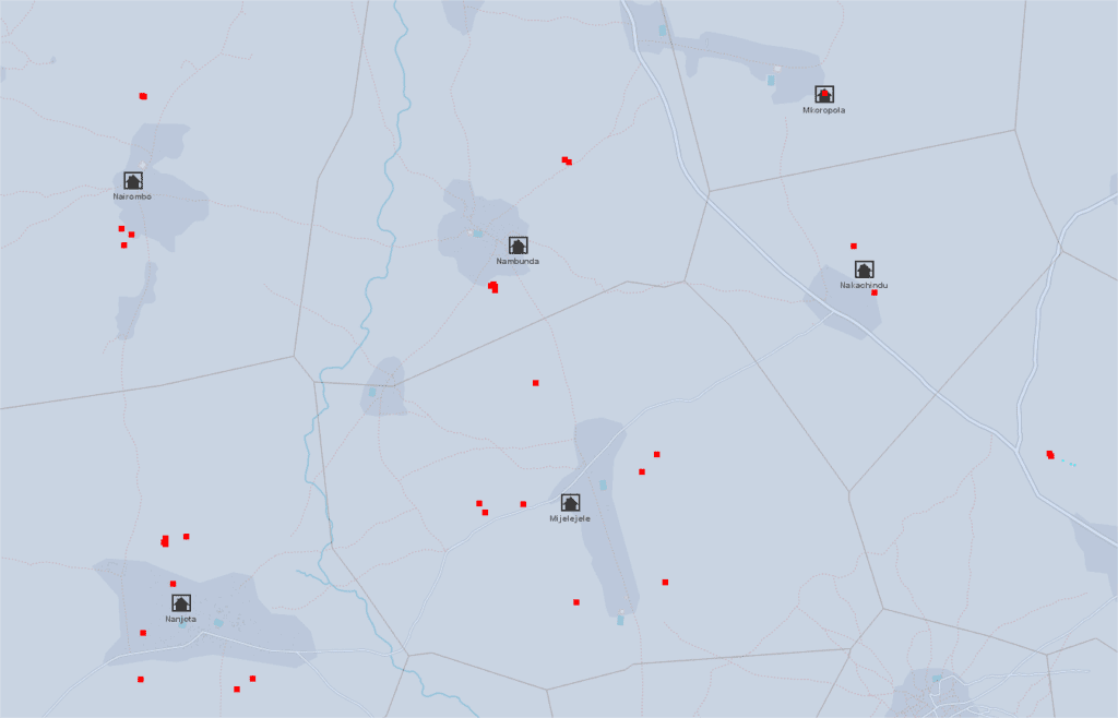
  1. Thyessen polygons were calculated from the water points layer, to get the influence zone of each water point. Then, the polygons were merged by attribute, where the village name is the same. The resulting polygons can help to determine the area where the village has to be.
  2. In the same time, Mean center was calculated for the points inside a polygon → potential position of the village. (Since in a few cases the name of a village occurs more than once in the country, a “village+district” combined data was used to help us to find the real mean center.) This is our village data POI which need to be implemented to OSM.
  3. OpenStreetMap imagery was used to identify the trace of human activity if the area was well mapped. We were also able to get an answer as to whether the name of the settlement has already been given to OSM. 
  4. Maxar satellite imagery was used for those areas that weren’t mapped yet. 
  5. Other useful datasets for validation
    • Waterpoints: can be really useful, if the position of the village’s POI is unusually far from any populated area. In this case, it is worth looking at how each water point is located in the area. Another example, when the village consists of two sub-villages, then the “SUBVILLAGE” attribute of the water database can help determine where the center of the village can be.
    • Health facilities data: The government data contains more than 7,000 health facilities like hospitals or clinics. The names of these facilities are usually, but not exclusively, the same as the name of the municipality where it is located. 
    • Education data: The government data contains almost 7,000 schools. The village names are available in this data. 

In summary

The Voronoi polygon assigns the area where the village is located (or has to be). The village POI assigns the potential location of the settlement, BUT its accuracy depends on the number of water abstraction points and their location in/around the given settlement.

In a well-mapped area - where, moreover, the settlements can be easily separated from each other - we did not have a difficult time with validation (mean centers before validation).
In a well-mapped area – where, moreover, the settlements can be easily separated from each other – we did not have a difficult time with validation (mean centers before validation).
The mean center of the Waterpoints sometimes clearly shows the center of the settlement if these water points are evenly distributed within and around the settlement.

Provisional results

By the end of September, more than 143 districts were validated (88% of all districts), and 5505 villages POIs were added which is 52% of the total village POIs in Tanzania.

User nameTotal edits
Bgabor1802
SHABANI MAGAWILA2255
Kasunga884
Stuart Ward49
Number of edits by users – which was added with “TNZ_missing_villages” hashtag

Crowd2map volunteers in the lead

The OSM database currently contains 10483 Tanzanian village points, a significant part was added by the volunteers of the Crowd2map team. The following pie chat shows how this 10483 POIs is divided between the TOP5 volunteers and the rest of mapper community:

Updated results – 31/10/2020

By the end of October, more than 157 districts were validated (97% of all districts), and 6759 villages POIs were added.

Against my will: A collaborative effort to end gender inequality

United Nations Population Fund (UNFPA) has published its State of the World Population 2020 paper. Against my will: Defying the practices that harm women and girls and undermine equality, has contributions from many important figures focused on improving female prospects globally through a combination of determination and ongoing action.

State of the world population 2020 cover

Rhobi Samwelly tells her harrowing story of experiencing near fatal female genital mutilation and seeing it kill her friend, and how this galvanised the founding of our partner organisation, Hope for Girls and Women. Rhobi is featured from page 67 of the report.
There is a wealth of important information about gender inequality within the document.  We were therefore keen to share it as a wider reading resource for those campaigning for an end to FGM and those interested in learning more about this and other practices that aim to prohibit the rights of women.

The full report can be downloaded via the UNFPA site from the button below:

Improving the impact of data from our partner, Hope for Girls and Women

‘Female Genital Mutilation’ and ‘data visualisation’ might not be two terms that you would immediately put together. However on June 1st, the Viz5 team and makeovermonday.co.uk did just that. Their global community of data enthusiasts were challenged to help communicate some of Hope for Girls and Women’s critical stats through a range of different visualisation techniques. 

Created byPriya Padham

Data can, at times, be quite impenetrable and dry. Being able to identify a logical flow and narrative using data visualisation techniques on a webpage, presentation or report, can help the information become more digestible and intuitive for the audience. According to t-sciences.com,  ‘the human brain processes images 60,000 times faster than text, and 90 percent of information transmitted to the brain is visual.’ 

Created byLiam Spencer

As part of the monthly #Viz5 data visualisation challenge, the team featured data from Hope in an effort to support our advocacy work and raise awareness of the fight to end FGM. There were so many great data visualisations produced! These were reviewed by Eva Murray, Technology Evangelist & Tableau Zen Master at Exasol and Seth Cochran, Founder & CEO at OpFistula.org.

  • You can see and hear the feedback they provided here.
  • The shortlisted visualisations are also available to view here.

Hope has a relationship with the Viz5 team through our association with the Tanzania Development Trust and Crowd2map. They have supported with our data collection and mapping of Tanzania, and were keen to use their platform to help us drive awareness around the challenges we face with FGM and the support we provide through the safe houses. Their passion comes across in the feedback session – we look forward to collaborating again soon!

To read more about the outstanding efforts and this important collaboration, please find the Viz5 article here.

Meet our mapping volunteers who are helping to end FGM in Tanzania

Female Genital Mutilation/Cutting (FGM/C) is a traditional practice prevalent in many parts of Africa and across the world. It is rooted in gender inequality and attempts to control a woman’s body. FGM in Tanzania secures a higher dowry for the parents of the girl who has undergone the procedure.  FGM was criminalised in 1998 in Tanzania, so it is frequently undertaken in secret and unhygienic, dangerous conditions. 

How can I help stop FGM?

Crowd2Map Tanzania is an entirely volunteer-based mapping project putting rural Tanzania on the map.  Having better open-source maps helps activists protect girls from FGM and supports navigation and community development.

Since 2015, over 13,000 remote volunteers worldwide, based in countries ranging from Poland to China, Brazil to the United States, to name a few, have been adding roads and buildings to digital maps and supporting the cause.

This year with the many challenges resulting from COVID-19, more than ever, we need all the support we can get to continue our mission to end FGM and get help to vulnerable girls faster.  You can volunteer from home, contributing to the first stage of mapping, as long as you have an internet connection, the team on the ground in Tanzania then completes the process using their local knowledge. Get started and find out more here.

Will you become a remote online volunteer?

Find out more about some of our volunteers here:

Katerina - Crowd2Map volunteer of the month January 2021
Crowd2Map volunteer Si Wilde
Crowd2Map volunteer Maria Cielecka
Image of Crowd 2 Map volunteer MaryAnn Obidike
Image of Crowd 2 Map volunteer, Pietro Fasciolo
Anshul Vohra - C2M volunteer

Emmanuel Uwinima - C2M volunteer
Maja Turkalj - C2M volunteer


16 Days of Activism Against Gender-Based Violence – an evolving campaign

“I first found out about the 16 Days Campaign when Rhobi Samwely organised a 16 Days March around Mugumu, Tanzania, in December 2015,” recounts Janet Chapman, Founder of Crowd2Map Tanzania.  Rhobi opened the Mugumu Safe House in 2014 to provide safety and support to girls at risk for genital mutilation in Tanzania.

“This was the first ever 16 Days March in Mugumu, and it stirred a lot of interest – and bemusement – on the part of the locals,” Janet said.  “About 200 girls marched around town singing ‘we want to be modern, uncut girls’ and demanding their rights.  As it turned out, the March itself was stewarded by local police, and this was an enormous step forward in forming a cooperative relationship between the officers and the Mugumu Safe House staff and residents.”

16 Days March around Mugumu, Tanzania, in December 2015

Founded in 1991, the 16 Days of Activism campaign runs annually from November 25th (International Day for the Elimination of Violence Against Women) to December 10th (International Human Rights Day).  The Campaign’s founding in 1991 followed, and commemorates, the December 6, 1989, deaths of 14 female students at the University of Montreal.  Often referred to as the Montreal Massacre, it involved a male student who entered the University’s Engineering Department and after declaring his intent to kill feminists, he shot and killed the 14 students.

The theme of the 2019 Campaign – Ending Gender-Based Violence in the World of Work – reflects and celebrates the passage in 2019 of Convention 190 (C190) by the International Labour Organisation (ILO) to address gender-based violence in the working world.  What is significant about C190 is that it is the ILO’s first Convention (which includes Recommendation 206 as guidance) to address sexual harassment and violence against women in the working world. 

Will C190 change anything?

The ILO Conventions are a type of treaty that commits ratifying member nations to a specific course of action.  Compliance is self-reported, and ILO conventions tend to act as benchmarks against which ratifying nation commits itself to strive toward.          

Created in 1919 as part of the Treaty of Versailles, the ILO is a specialised United Nations agency, sometimes referred to as an international parliament of labour.  It acts as a forum where social and labour questions are discussed and debated.  In recent decades, ILO members have expressed concerns about poor working conditions in the global economy – where inequality and displacement of workers continues to increase. 

Christine Lagarde, former Managing Director of the International Monetary Fund (IMF) and current head of the European Central Bank, said she made female empowerment a key goal for the IMF.  “I didn’t see #MeToo coming but I welcome it immensely,” Lagarde said.  “Sexual harassment is only scratching the surface. Violence against women is still a massive issue and we are not just talking about low-income countries: it is in all societies.  It has to be discussed, addressed and fought against. There are some terrible things happening to women.”

One alternative that has been discussed is to incorporate ILO labour standards into the World Trade Organisation, where member nations could retaliate for unjust practices through trade sanctions. 

Hiring more women helps drive economic growth

According to Lagarde, 88% of all countries in the world have legal restrictions against women in the workplace. “Some [nations] forbid women from doing specific jobs, 59 countries have no laws against sexual harassment in the workplace and there are 18 countries where women can be legally prevented from working,” she reports.  A 2019 ILO report on global employment also cites the lack of progress in closing the gender gap in labour force participation – 48% female compared to 75% male. 

The IMF is already pushing member nations to implement policies that empower women, Lagarde said, noting that women bring new skills to the workplace and help boost productivity – as well as workforce size.  The empowerment of women results in “higher growth, a reduction in inequality, an improvement in the strength of the economy and a more diversified, export-focused country,” she reports.

Even advanced countries need improvement, she contends – the female workforce participation in such countries is still way below that of men, and the gender pay gap among developed countries is approximately 16%.  But at the same time, some nations are making progress.  Lagarde lauded Japan in particular for increasing its childcare budget, which takes some of the burden off working mothers.

To their credit, some nations have already addressed intimate partner violence by providing support for affected workers.  In 2004, the Philippines became the first country to establish 10 days paid leave of absence for workers affected by domestic violence.  New Zealand adopted a similar law in 2018.  Collective bargaining agreements in countries such as Australia, Brazil, Canada, and the United Kingdom now provide paid leave and other entitlements to victims of domestic violence.

Addressing misconduct in the workplace

Prevention is about giving workers multiple options, such as offering a hotline, or an opportunity to speak with the personnel department or with their manager, according to labour lawyer Amy Oppenheimer.  “If you are only providing employees one means of recourse, you’re inevitably deterring a big chunk of the workforce,” she said, adding that employers often need multiple tools for dealing with misconduct – such as bystander training, mediation and alternative dispute resolution, or training about communication and respect.  

Sexual harassment is often triggered by an imbalance of power, so the emergence of women into leadership positions does make a difference.  “When you have at least some women in leadership, there’s a very subtle but important cultural change that takes place, and it’s that kind of change that really is the foundation for eliminating sexual harassment,” reports Stephanie A. Scharf, chair of the American Bar Association’s Commission on Women in the Profession.

The following organisations focus on the promotion of women’s rights. 

To volunteer, apply for an internship or a job, or to find services and support, contact any of the following:

BAOBAB for Women’s Human Rights. 323A, Muri Okunola Street, P.S. Box 73630, Victoria Island, Lagos, Nigeria. Tel: 234-1-262 6267.  www.baobabwomenorg.  Focused on women’s legal rights issues under customary, statutory and religious laws in Nigeria.

Center for Reproductive Rights. 199 Water Street, New York, NY 10038, 917-637-3600:  www.reproductiverights.org.  Nonprofit legal advocacy organization dedicated to promoting and defending women’s reproductive rights worldwide.  Offices located in Washington DC; Bogota, Columbia; Nairobi, Kenya; Kathmandu, Nepal; and Geneva, Switzerland.

Equality Now. 125 Maiden Lane, 9th Floor, Suite B, New York, NY 10038. 212-586-1611.  www.equalitynow.org.  Committed to ending violence against women around the world.  Offices in London UK and Nairobi, Kenya.

Federation of Women’s Lawyers Kenya (FIDA Kenya), P.O. Box 46324, Gitanga Road, Nairobi, Kenya. Tel: 722509760.  www.fidakenya.org.  Objective is to increase access to justice for women in Kenya and enhance pubic awareness of women’s rights.

Global Justice Center. 11 Hanover Square, 6th Floor, New York, NY 10005. Tel: 212-725-6530. www.globaljusticecenter.net. Lawyers and advocates who specialize in international law for the purpose of advancing gender equality and human rights.

International Rescue Committee. 122 East 42nd Street, New York, NY, 10168-1289. Tel: 212-551-3179.  www.rescue.org.  Providing assistance to people whose lives and livelihoods have been shattered by conflict and disaster.

Legal Momentum.  32 Broadway, Suite 1801, New York, NY 10004. Tel: 212-925-6635.  www.legalmomentum.org.  Legal advocacy organization dedicated to advancing the rights of women and girls. Programs focus on human trafficking, workplace equality, violence against women and girls, equal education opportunities, and fairness in the courts. 

National Coalition Against Domestic Violence. 600 Grant, Suite 750, Denver, Colorado 80203. Tel: 303-839-1852.  www.ncadv.org.  Mission is to support efforts to demand a change in conditions leading to domestic violence, supporting survivors, and holding offenders accountable.

National Partnership for Women and Families.  1875 Connecticut Ave., NW, Suite 650, Washington, DC 20009.  202-986-2600.  www.nationalpartnership.org.  Advocates for women’s health, reproductive rights, and economic justice through policy research, participation in coalitions, and public education.

Pace Women’s Justice Center.  78 N. Broadway, White Plains, NY 10603. Tel: 914-422-4188. www.law.pace.edu/bwjc.  Legal services for victims of domestic violence, sexual assault, and elder abuse.    

UN Women. United Nations Secretariat, 405 East 42nd Street, New York, NY 10017-3599. www.unwomen.org.   Mission is to develop and uphold standards and create an environment in which every woman and girl can exercise her human rights and live up to her potential.  Liaison offices in Denmark, United Arab Emirates, Belgium, Ethiopia, United States, Japan, and Switzerland.  Numerous regional office in Africa, Americas and Caribbean, Arab States, Asia and the Pacific, and Europe and Central Asia.   

Women’s Initiatives for Gender Justice.  Noordwal 10 2513 EA The Hague, The Netherlands.  Tel: +31 (70) 302 9911.  www.iccwomen.org.  This office works with women most affected by conflict situations under investigation by the International Criminal Court (ICC).  They advocate for accountability & prosecution of sexual and gender-based violence crimes and gender justice through the International Criminal Court (ICC) and domestic courts.

Women’s Refugee Commission.  15 West 37th Street, 9th Floor, New York, NY 10018. Tel: 212-551-3115.  www.womenscommission.org. They work to improve the lives and protect the rights of women and children displaced by conflict and violence.  

Women’s Legal Centre. 7th Floor Constitution House, 124 Adderley Str., Cape Town, South Africa. www.wice.co.za.  Established by a group of women lawyers to advance women’s rights – particularly vulnerable and marginalised women – and to promote their access to justice and equitable resources.    

Zimbabwe Lawyers for Human Rights.  Kodzero/Amalungelo House, No. 103 Sam Nujoma (2nd) Street, Harare, Zimbabwe.  www.zlhr.org.  Mission is to protect and defend human rights through sustainable litigation, education and advocacy and help build a culture of tolerance and adherence to democratic values and practices.

Resources
Mugumu Safe House
16 Days of Activism
Convention 190
International Labour Organization     
ILO Conventions
Treaty of Versailles
International Monetary Fund   
European Central Bank
World Trade Organization

A marathon that changed my life…

Pedro takes us on the journey that has seen him become a volunteer contributor

One of my favourite hobbies is running. I like to run marathons and felt that it did me good. However, over time (and in my native Portugal), I have come to realise that amateur athletes are increasingly trying to be professional runners. With this, the feeling of help and availability to others is less. I have watched a lot of athletes who get hurt or feel bad in amateur racing and almost no one helps because it doesn’t improve their personal records!

I participated in the Athens marathon, and had a muscle break at km 15. Another athlete realised my suffering in continuing the race and decided to “abdicate” his personal record to accompany me. He didn’t know me but he did this for me. Throughout the race he told me that each marathon has a history, and this is the medal that is important. Not how fast you run, but the good you can do.

It opened my horizons. From that day, I decided that I could be like him myself. No matter how fast I run, how much money I make, or food I have, there are people around the world who have none of this. Then I started thinking about what I could do to help the world. The first thing I did was open the UN Volunteers website. I saw what I could contribute and shortly after I arrived at the Tanzania Development Trust. I started mapping and giving up some time spent marathon training to help those in need and at risk of FGM. My goal is now!

Find out more here about how you can also become a volunteer contributor from anywhere in the world.

Pedro is a keen marathon runner and now volunteers for Crowd2Map
Pedro is a keen marathon runner and also finds time to volunteer for Crowd2Map.

Missing Maps is 5

When I first realised the need for maps in Tanzania 4 years ago and started Crowd2Map I had not heard of Missing Maps. However about 3 months in I came across the very active and friendly London group which I have been attending fortnightly ever since, and their support and advice has been invaluable.  This week Missing Maps turned 5, a time of reflection for the founders including Ivan Gayton.

He originally envisioned it as a finite endeavour that shouldn’t last more than 4 years, and states “The idea was: what if instead of relying on media coverage of crises to generate volunteer engagement to map after disasters had already struck, we used the power of humanitarian movements to build a community to map the homes of vulnerable people before disasters?

In Haiti in 2010, using OpenStreetMap data was an interesting new idea, practiced by a couple of innovators alongside the “proper, professional GIS” being done by the cluster coordination. By the time Typhoon Haiyan hit the Philippines in 2013, OpenStreetMap was at least co-equal with the closed data. In the West African Ebola outbreak in 2014 open, community-generated map data was unquestionably the dominant source of geographical information. Open map data is now the default for humanitarian and crisis response.

So why didn’t we declare victory and move on? Why do we still need the Missing Maps? Because what I had originally seen as success turned out to be no more than a starting point. I had failed to anticipate the range of uses for open map data. I was focused on patient origins and spatial epidemiology—still critically important but not the only impactful use—and did not realize the importance and possibilities of locally-driven field mapping. The remote volunteering and mapathons, which attracted a startlingly diverse and extraordinarily passionate volunteer community, have now largely accomplished the original goal of creating the base-map vector features in some places. There’s more to be done, to be sure, but the key gap in many places is no longer digitization, its local knowledge and ways to operationalize the data.

The ultimate goal of humanitarian action is to save life, alleviate suffering, and restore dignity. Mappers cannot claim to save lives directly; if we are to have an impact it is by facilitating those who are saving lives (or helping themselves). To reach its full potential, the Missing Maps must not only provide basemap data, but to enrich them with local knowledge and see that the maps are put to use.

I now see three phases of Missing Maps action:

1) Create a base layer of vector data across the most vulnerable areas of the globe using digital volunteers

2) Infuse local knowledge into the map using field mapping campaigns in collaboration with local people (the most critical local knowledge being local place-names, landmarks, and administrative divisions—without which we cannot disambiguate locations described by people in their own words).

3) Actively partner with people working to save lives, alleviate suffering, and restore dignity to make them more effective using our data, skills, and knowledge.

The Missing Maps has basically succeeded at phase one in many places. Phase two is in progress; many of us are increasingly engaged in work with local communities to add the local information to the map that makes it useful and relevant to people working in these contexts. Phase three has, in my view, not yet even properly begun. Sure, a few well-funded agencies have better GIS support as a result of the Missing Maps, and there are sporadic uses of Missing Maps data arising spontaneously here and there throughout the humanitarian field, but humanitarian action and crisis response are still nowhere near achieving the additional effectiveness that a truly inclusive global community of mapping practice could provide.

For example, in the current Ebola outbreak in the Democratic Republic of the Congo, patient origins are still poorly understood. This is not even to speak of the colossal gap in disease surveillance throughout the low-income world, the lack of accurate demographic data for public health and services, the desperate lack of transparency in land titles, or the difficulty in navigating the more or less informal settlements that one-quarter of humanity live in. The Missing Maps should be saving and improving many more lives. It can do so once we are working directly with people on the front lines, understanding their problems and constraints, and working with them to operationalize map data.

There are hundreds of thousands of health centres in Africa awaiting the support needed to properly understand their patients’ origins and act upon them to reduce disease burdens. There are aid agencies, civil servants, private businesses, taxi drivers, public health ministries, environmental activists, scientists, farmers, and pizza delivery bicyclists waiting for our help (in some cases whether they know it or not). The Missing Maps must become much more than a digital volunteer community, it must become an inclusive global movement to empower all of the things that save and improve lives.

Finally, maps themselves can in some small way contribute to human dignity. To be on a map is to be acknowledged, is to be known, is to be recognised, is to be counted. It is for the world to know that you are there and that you have needs, that you have rights, and that you must not be forgotten or passed over. This requires more than a nice map on the Web made by digital volunteers and aid agencies, it requires working together with the inhabitants of the previously neglected places in the world. Five years in, the Missing Maps has seen success beyond our wildest dreams. But it turns out the work is just beginning, and we must go beyond our original digital volunteering mandate to achieve our full potential. Let’s get to it, shall we?”

Thank you to Ivan for expressing the rationale behind Crowd2Map so clearly.  We want to partner with anyone interested in mapping for development in Tanzania and beyond – so if you any suggestions please do get in touch. 

Circling the World with OpenStreetMap

Imagine that you are able to look down from a great height, over any region of the world, and view villages and farms in great detail. You might see, for example, what appears to be a well-trod footpath that bypasses a shed or a goat pen, or a building tagged as a school but with no playground or soccer field.  You see no paved roads or sidewalks.  What would it be like to exist in this world that you are viewing? 

Mapping on OpenStreetMap (OSM) offers a challenge.  But anyone who has experienced it can testify to how it magically takes us to unfamiliar corners of the world to peer into remote towns and villages.  It offers us a view into the lives of people who not only look different from ourselves but who might also be living on the edge of starvation.  In a humanitarian context, the experience of mapping can be transformational, especially when used to help at-risk populations, such as the young women of Tanzania.    

Mapping to End Female Genital Mutilation

Although the practice of female genital mutilation (FGM) remains illegal in Tanzania, many young Tanzanian females, especially those living in remote regions of the country, are subjected to this practice.  This past September, Janet Chapman gave a presentation at the State of the Map (SOTM) Conference in Heidelberg, Germany, on the progress being made on Crowd2MapTanzania

One of Crowd2Map’s primary goals is to protect girls against FGM, and the initiative has made remarkable progress.  Nearly 12,000 volunteers around the world have already added 3.6 million buildings to OpenStreetMap (OSM), using satellite images to trace buildings.  These remote volunteers access the Slack Channel, which now has 3,000 members, to ask questions or receive feedback.  On the ground in Tanzania, over 1,600 activists use smart phones to add villages, schools, hospitals, clinics, offices, shops, churches, and safe houses to the OSM maps.  

As a Trustee of Tanzania Development Trust and its Communications Manager, Janet has been spending at least two months a year in Tanzania for the last six years. From her time on the ground, it was clear to her that mapping was badly needed.  So, in November 2015, she founded Crowd2Map Tanzania to protect Tanzanian girls from FGM but also to promote community development.

Past efforts to provide protection and support to girls at risk of FGM have always been greatly “hindered by lack of mapping,” Janet noted, and that lack has made regional travel difficult.  “Without maps, young Tanzanian girls cannot find safe houses, and sanctuary from FGM practices. And safe house staff members and police officers cannot find girls at risk for FGM.”

One of the principal activists on the ground in Tanzania is Rhobi Samwelly, who set up the Mugumu Safe House, where girls can find safety and support.  Rhobi herself could have died from FGM.  “When she was cut at the age of 13, Rhobi almost bled to death,” Janet told her audience in Heidelberg. “Her girlfriend had been cut and she died, and her body was left in bushes surrounding the village.” 

Because it is illegal, the practice of cutting is largely performed without medical personnel present. Rhobi’s ultimate goal is to place an activist in all villages, so that the village activist can become someone girls at risk will turn to for protection and transport to a safe house.   For further information about FGM, see 28toomany.org/country/tanzania.

State of the Map (Heidekberg 2019)

Like other 2nd generation World Wide Web tools, OSM draws much of its influence from community participation around the globe.  Representatives from humanitarian, recreational, governmental, and academic attended the 2019 State of the Map Conference in Heidelberg to present their work and share their concerns.

“I’ve been involved in the OSM community for four years now,” reports Janet Chapman, and it was fantastic to meet up with people in Heidelberg who I generally only see once a year at such events and find out how their work is progressing. 

 “Plus, I had the opportunity to meet new people who are also doing amazing things, she added.  “One of the projects we are most interested in is the use of machine learning to speed up the mapping process.  We have already set up some pilot projects and are excited about the results.  We will start rolling this out soon, on wider basis.”

Before exploring how machine learning, (a type of artificial intelligence based on patterns and inference, using algorithms and statistical models) will transform mapping, let’s briefly review some of the numerous OSM mapping projects presented at the SOTM Conference.

Cycling

Those interested in urban and touring biking had excellent opportunities to connect, learn, and share concerns.  For instance, a group of activists from Medellin, Columbia, shared their work on mapping the cities of the Aburrá Valley, with Medellin as a core city. Drawn in part from the GEOLab Research group at the University of Antioquia, these cycling activists are using OSM to map existing infrastructure and provide visualization of safety data (including air quality), with the goal of making cycling safer and more attractive.

Likewise, representatives from Nomad Maps talked about their goal of creating a community of “NomadMappers” in Columbia, Ecuador, and Peru. They will map on both OSM and Mapillary in order to assist cyclists in their travels across the Andes Mountains.    

Members of CyclOSM presented their cycling render of Paris, which built on the excellent quality of OSM’s Paris data.  Their work differentiates bidirectional ways and dedicated lanes versus shared lanes (bike lanes are often indistinguishable from car lanes), and also pinpoints bumps and bike boxes. 

Indoor and Outdoor Walkways

Mapping pedestrian walkways and paths presents challenges. Hikar, an augmented reality app for Android, is experimenting with the use of augmented reality in conjunction with OSM.  Once restricted to England and Wales, Hikar now covers Europe and shows distance and direction. 

On-the-ground navigation for those with mobility impairments, presents a different sort of challenge.  In England, the Stockport Council initiated the ‘Mapping Mobility Stockport’ project to address navigation barriers to individuals with vision impairments or wheelchairs.  They collaborated with community members to develop strategies for negotiating such barriers, thus transforming the project into a share community effort. 

The French railway company SNCF has created a dedicated routing engine to navigate indoors and outdoors at 83 train stations in Paris.  SNCF has also incorporated landmarks (replacing certain written instructions) onto their railway station maps.           

Public Transportation

SNCF has adapted GraphHopper, used primarily for graph-based car, pedestrian, and bike navigation, to work with OSM rail data.  SNCF calls their initiative OpenRailRouting, and it has resulted in upgraded services, such as delay calculations, tunnel positioning, and distance calculation.  

In Norway, Entur maintains a national registry of data for 60 public transportation operators, using OSM as a foundation for routing.  Entur plans to broaden its scope to all of Europe and will continue to build on its use of OSM, OpenTripPlanner, and other open-source platforms to do so. 

Community Development and Disaster Preparedness

In central Scotland, the Falkirk Council used OSM to create Our Falkirk.  Poverty estimates run as high as 25% in Falkirk, and their map-based tool provides information to the community on local services that provide social support, food supplies, financial advice, and digital access.

OSM is being used to determining the need for bridge infrastructure in the Kingdom of eSwatini.  To determine the need for additional bridges, the region’s baseline accessibility (to a bridge) is compared to its accessibility during a flood or rising water levels.  Similarly, OSM is being used in Nepal and in the Philippines, to strengthen disaster preparedness. 

Artificial and learned intelligence Support Each Other on OSM

The inclusion of the Academic track in the annual SOTM Conference provides a look at some interesting research on the effects of mapping on volunteers, using YouthMappers as subjects.  According to Patricia Solis, such research suggests that the humanitarian nature of many mapping tasks often softens the grinding task of learning a new technology, making it a more compelling challenge.  Because humanitarian mapping often awakens volunteers to the ordeals in other people’s lives, the experience itself often leads to more positive outcomes, such as satisfaction or a newly found interest in technology.  Research also indicates that the experience of mapping helps develop valuable geospatial skills in young people, skills may help them land an internship or job offer, according to Patricia Solis and Sushil Rajagopalan.  They indicated that the effects are particularly strong for females.

Equipping a younger generation with geospatial skills, already highly valued in the marketplace, may be greatly enhanced by the expansion of OSM’s functionalities with machine learning.  In July of 2019, Facebook released Map With AI, which is now available to OSM and provides access to Tanzania (as well as Mexico, Nigeria, Uganda, Indonesia, Bangladesh, and Afghanistan). 

Map With AI comes with an AI-powered OSM editing tool called RapiD, which acts as its interface.  Like flipping a switch to turn on the overhead lights, mappers will use RapiD to review the model’s identified navigation patterns of paved and unpaved roads and paths (as opposed to dried up riverbeds) and highlight them on OSM.  The identified, or “predicted,” roads and paths are given a confidence rating, which is expressed as a magenta overlay.  Existing roads show up with a white overlay.

Tested by Facebook and OSM reviewers on 300,000 miles of unmapped roads in Thailand, the Map With AI has been shown to accelerate the process of road mapping. Given the extent of the numerous mapping projects, and the education it is providing in geospatial skills, Facebook’s AI model can only enhance and accelerate OSM’s crowdsourcing work around the globe.

Reflecting on the inspiring ICPD25

ICPD25 in Nairobi was an amazing event and I was extremely proud to run a Female Genital Mutilation (FGM) mapathon there on behalf of United Nations Population Fund (UNFPA). 9500 people from 170 countries attended the summit, from heads of state and UN employees to grassroots activists. 

I attended some amazing talks and workshops which included huge declarations from the Kenyan President to end FGM by 2022 and much smaller events. I met with familiar activists I’d spoken to before plus many new people with additional opportunities for collaboration. Some highlights for me included:

·       Rebeca Gyumi talking about her social media campaign against child marriage and FGM in our mapathon

·       Finally meeting Francis from The Network against Female Genital Mutilation (NAFGEM), who was talking at the Human Library about the value of generational dialogues in eliminating FGM

·       Hearing Tony Mwebia talk about his initiative #MenEndFGM and helping many of this group get started with mapping in Kenya

·       Meeting again Laura Mugeha and her colleagues from Women in GIS – doing amazing visualisations on gender – and persuading Laura to do a talk about Crowd2Map at State of the Map Africa, Ivory Coast (November 22-24) 

Plus very many contacts to follow up with. We have a busy few weeks through to the end of 2019 and will be proactively looking to get in touch with our new contacts as we move into 2020.

If you didn’t make it to the mapathon in Nairobi there is more information on the work we do with the support of volunteers around the world, on this site.  There is another online mapathon planned for 1st December and on 3rd December we will hold a mapathon in London, UK.

Map with us in Nairobi this November

We’re excited to bring mapping and our FGM campaign work to a global audience at the Nairobi Summit on ICPD25 in November. On Thursday 14th we will be running a workshop including a Mapathon which is open to attend to those already registered to the Summit.

2019 marks 25 years since the International Conference on Population and Development (ICPD) agreed a much-needed Programme of Action must be put in place, established by governments from 179 nations. The Programme of Action is an acknowledgement and understanding that reproductive health, women’s empowerment and gender equality form the pathway to sustainable development. This message is important globally and critical for communities across Tanzania and other East African nations and is being explored at the Summit.

Crowd2Map founder Janet Chapman along with Hope for Girls and Women founder Rhobi Samwelly will be delivering a mapping workshop at the Summit to share the impact this volunteer-driven pioneering digital activity is playing on the ground to help protect girls who are at risk of, or who have been through, FGM. With mapping also having been found to have a positive impact beyond FGM, this is an important stage on which to share the significance of the work we do.

Close up of mapping on a phone

We now have contributors from all over the world who are committed to bringing more visual guidance to those trying to reach and rescue vulnerable girls, as well as those wishing to escape challenging situations and beliefs. Tanzanians complete the process adding additional local knowledge and detail to the work delivered from afar.  With our effort in Tanzania proven to have been so successful, we are now keen to extend our mapping work to protect girls and women in communities further afield.

It promises to be an impressive event and we’re grateful and enthused to have this opportunity to bring mapping in front of a wider audience. Whilst there we will also meeting with FGM activists and looking to strengthen and broaden our network by meeting with other delegates.

Those wishing to attend need to be registered. More information about the Nairobi summit can be found at https://www.nairobisummiticpd.org/.

Follow us on social media to get updates on the run up and during the event. If you’re unable to attend the workshop but would like to meet at the Summit, please email j.chapman@tanzdevtrust.org.