Our progress covered by The Missing Maps: http://www.missingmaps.org/blog/2017/02/20/fighting-fgm-in-tanzania/

Our progress covered by The Missing Maps: http://www.missingmaps.org/blog/2017/02/20/fighting-fgm-in-tanzania/
We are proud to announce that our project was covered in The Guardian by Sophie Tremblay – the same journalist who made this excellent video about the project.

https://www.theguardian.com/society/2017/feb/06/online-mapping-tool-gives-fgm-runaways-a-path-to-help
Tanzanian edition:

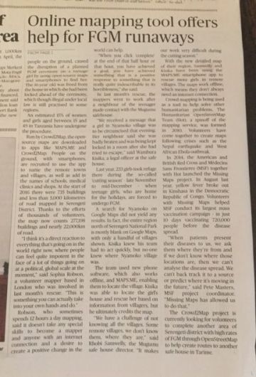
ast month a local freelance journalist in Tanzania – Sophie Tremblay (follow her for more amazing local news) – reached out to us, wanting to cover the work we do – mapping to end Female Genital Mutilation (FGM) in Serengeti region, Tanzania.
See the amazing video below by AJ+ news, featuring Mugumu Safe House & how maps WE create at Crowd2Map help them do their important work:
Anticipated for December, we have received word that the FGM season has started already in the Mara region of Tanzania. We are rushing to map two tasks that will help Mugumu Safe House workers to identify & reach villages at risk:
http://tasks.hotosm.org/project/1788
http://tasks.hotosm.org/project/2261
All you need is a PC and a mouse. Here’s an excellent instructional video, and detailed PDF instructions on how to get started.
Remember – every bit of land mapped makes a difference.


Crowd2Map had a great time presenting at Mozfest in London last weekend. We had a session in the science fair on Friday night and signed up a lot of new people to help map the area of Serengeti where girls are most at risk of Female Genital Mutilation via mapping from satellite images here. Then we delivered a workshop on Sunday to actually get people mapping (all the notes from the session can be found in the Etherpad here), complete with a live link to the Safe House in Mugumu, and presented our map at the show party on Sunday.
Coupled with doing 4 interviews, meeting hundreds of amazing people and even being chased by monks it was a brilliant weekend. BUT, on a serious note, we are desperately trying to get the map of Serengeti complete before the FGM cutting season starts in 3 weeks time. Please help us here.
Notes from our Mozfest session: https://public.etherpad-mozilla.org/p/mozfest-2016-towards-sustainable-development–crow


We are presenting today at HOT Summit in Brussels! Here is our talk:
[slideshare id=66433764&doc=hotcrowd2mapwithexplanationboxes-160926172245]
Our State of the Map lighting talk & workshop “Improving canvas for participatory mapping in Tanzania” are coming on Saturday!

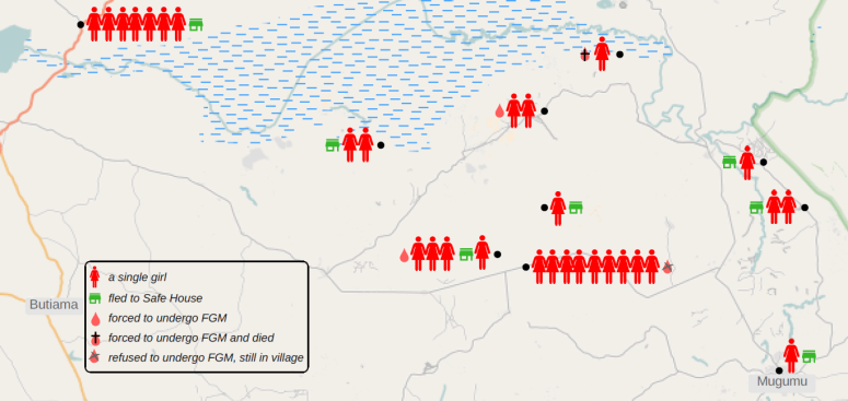
Received a note from Wambura Kisika, the legal officer at the Mugumu Safe House! Here it is, in his own words, why our mapping is helping their crucial effort to fight FGM:
On our side we are doing fine at the safe house. The map is very important because most of the villages where the girls come from are remote areas, there no passable ways, no bridges for the rivers, settlements are scattered and some areas with some dangerous animals, so as can remember we are working with volunteers who informs us about the incidents in villages, during the cutting season when we are informed of the incident we have to know the road to that particular place which is passable, the volunteers also should know the road where we can meet and the girls also have to know the road to the safe house.
Currently we using the map to reach some place where we never reached before, educating them about the effects of FGM and making demonstration for those who would like to run to the safe house during the cutting season we are also thinking to use the map distance to plan the fuel budget for collecting some girls who will fail to reach the safe house and during returning them back home…– Wambura Kisika, Mugumu Safe House
We’ve been mapping the are around Mugumu in Tanzania, where female genital mutilation (FGM) – the tradition that threatens the life and health of women – is still prevalent.
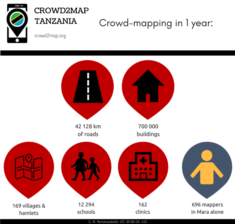
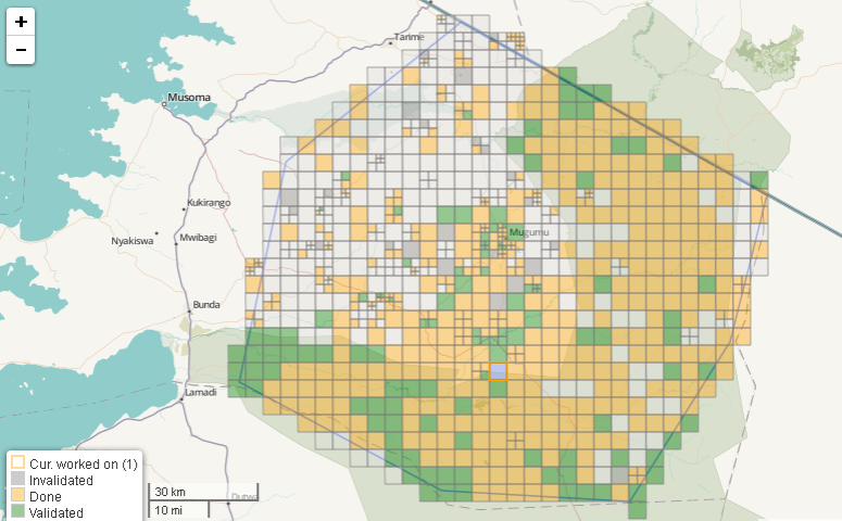
With the help of our online volunteers and an army of recent mapathon mappers, our task on HOT tasking manager, which covers a large proportion of Mara region, is already 65% done!
Rhobi Samwelly, the founder of Mugumu Safe House & Vocational Training Center explains why mapping helps her cause:
Before we started mapping, there were 1, 522 km of roads in the region of Mara.
Now there are 7,005 km.
Before we began, there were 2, 807 buildings in the area of Mara.
Now there are 47,480.

Yep, that’s all you need – and your efforts may help protect thousands of girls from FGM next winter.

8 mappers in Vilnius, 26+ in London, 32 in Dar, 15 in Nairobi, 15 at Mugumu Safe House and many others online joined our mapping party last Saturday!
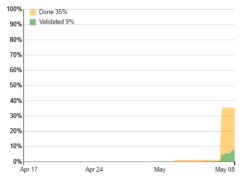
Thanks to all of you we were able to map over one third of the entire region in Mara!!
Congratulations all users who were able to map an amazing number of squares. You can also check your own contribution on roads and buildings here.
Thanks also to Polyglot and robert, who have been validating our squares so far !!
Mappers in Vilnius, Dar, London and Uganda shared their progress on Twitter: See full Twitter day here and here on Storify.
Benedicto joined us from Zeze…

Great work, I am with you from Zeze village – Benedicto
…and Tunapanda from Nairobi! Thanks so much guys!!

15 of us learning to get our map on in Kibera, Nairobi – Jay
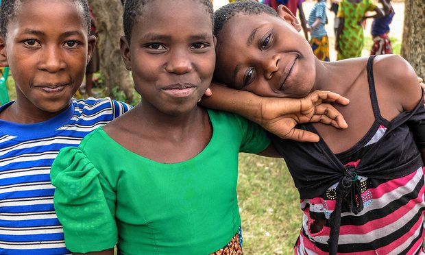
Girls at Mugumu Safe House took matters into their own hands and joined us in mapping all day!! Thanks to Rhobi who takes care of the safe house, IT teacher Irene, roadshow Emanuel & the girls at the safe house!
We are very excited to map our Tanzania, here with Madam Rhobi – Irene
We ended the session with so much smile – Irene
More mappers in London!
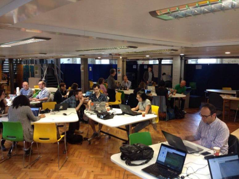
London in action – Andrew
Happy mapping in Dar!

And finally…
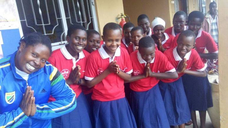
Appreciations and so much thanks from the Safe House for great experience acquired during mapping – Rhobi

We will be concentrating on mapping the Serengeti district around Mugumu during our Triple Mapping Day on May 7th.
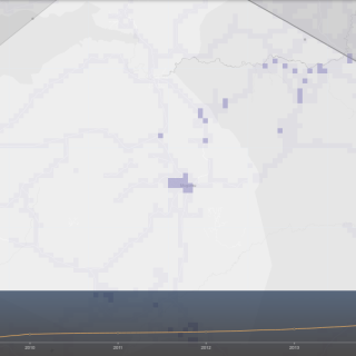
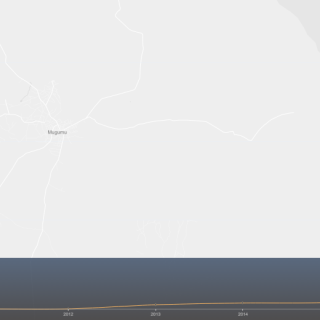
Thanks to some nifty tools recently developed in the OSM community, we’ll be able to visualize our impact with OSM analytics!
Playing about with it just now, I discovered that already a noticeable amount of work has been done in 2016, partially thanks to our mapping volunteers!! Blank canvas is already turning into something resembling a map, see for yourself:
Roads before 2016:

… and now (4 months into 2016!):
Buildings around Mugumubefore 2016:
… and now (4 months into 2016!):

Which team will map the most? Vilnius? London? Dar?
Join us & be one of the Crowd2Map !